Benito Juárez National Park
So far, I haven’t done much hiking in Mexico, and since Benito Juárez National Park was near Oaxaca de Juárez, I thought it would be a good idea to spend the day there. Immediately, there was a problem- I couldn’t figure out how to get to the national park. After looking around online and finding no information in English, I went to the nearby tourist information center, and when I asked about the park he had no idea what I was talking about. I showed it to him on the map, and he referred to it as “Sierra Juárez”. He told me to get a bus to the stadium and from there to take a “colectivo”. I later asked at the hostel reception, this time saying Sierra Juárez and not Benito Juárez National Park. I got a very similar answer.
Unsure about the whole thing, I took the bus to the stadium, a day before I planned to go hiking, just to make sure it’s not going to be a problem. When I got there, I had to look around for a few minutes, consulted Google Maps, and found myself in an area where quite a few people were waiting, mainly for taxis. When a bus showed up, I asked about Sierra Juárez, but it wasn’t the right bus to take. I waited a while longer, no buses or vans showed up, and I went inside a nearby store to ask if I’m in the right place. The answer I got was that the only way would be to get a taxi. Disappointed, I went back to the hostel.
The next thing I tried was to do a google search in Spanish. Once again, I found no useful information, although it is a possibility that my Spanish was simply not good enough. Then, finally, I decided to ask reddit, and I got a few responses which made me think I can get to the national park after all. I also got a bit more information about the whole thing, and it seemed that Sierra Juárez is a mountain range, and the national park is located there. And to add to the confusion, there might be more than one entrance/exit point.
The following morning didn’t start too well. I had breakfast later than I intended, packed my bag, made sure I understood what to do and where to go, and by the time I left the hostel and found what google and the people I asked said is the bus stop, I had to wait there for nearly half an hour. And when the bus came in, it didn’t stop.
It was getting late, and instead of waiting around for another bus that may or may not show up, I headed to a nearby place where a few taxis were waiting. When I asked them about Benito Juárez National Park, they had no idea what I’m talking about, even after I showed it to them on the map. I’m still not sure how no one seems to know about a nearby national park, that was (and still is) very confusing for me.
I was just about ready to give up on the park, when I decided to try to name other places in the area, which worked better. The first driver I talked to wanted more than I was willing to pay. The second driver had a more reasonable price, although I did ask him for a different landmark. The landmark was a small park, which at first I thought was pretty close to where I wanted to end up, but it was quite a bit further away.
When we got there, I thanked the driver and after looking around briefly, I started to walk toward the San Felipe Terminal, which is where I tried to get to by bus. From there, there was a dirt road that was going to lead me to the national park. Somewhere on the road I spotted a bus, and got on it for less than 5 minutes before we made it to the terminal. Finally, I was there.
And so, with earbuds in my ears and music playing, I started my walk to the national park. At first I was walking on roads within the city, but after going up a steep uphill the paved road was over and I was on the dirt road. I had a nice view of the city, when it wasn’t obstructed by any buildings, the sun was about, and I started to feel like things were falling into place. Every now and then I would consult with the map, just to make sure I’m heading in the right direction, but for the most part the road was very clear and not difficult to follow.
And then, nearly three hours after I planned to get there, I saw a gate with a sign that said “Ejido Donají”. It was mentioned in one of the responses I got online, as a kind of ecotourism park within the national park. I passed through the gate, some no one, and noticed a view point very close by. Just before I got there I heard someone calling to me. Official or not, that man charged me twenty pesos, and told me that in order to get to Benito Juárez National Park I need to keep walking along the trail.
After paying, I had a little look around before I started the hike. At first I was just walking along the Ejido Donají park, passing a children’s playground area and a little garden. Gradually, I left it behind me and the dirt road became a bit less interesting. I had some trees to look at, and when there was a little gap I could see a bit of a view, but not much more than that. Thinking it’s best to just put this part behind me, I just kept going, wondering how long it would take and what I might see in the park.
Some parts of the path were sunny, and others were shaded, without clear consistency. I didn’t see the need to stop until I got to the sign that indicated a split in the road, which I assumed was the end of Ejido Donají. I had the options to go right, taking a short road (although it wasn’t clear how short) to a viewpoint, or go left, toward a name I didn’t understand, but the sign did indicate it was five kilometers away. I had no real time pressure, as there were a good few hours before the closing time indicated on google (although I didn’t verify it with the guy at the entrance), and I hoped the longer road would be more challenging as well as more rewarding.
After a moment of confusion, I found the right path and started walking. Being on a mountain, naturally the road was going up, although it wasn’t steep and didn’t require a lot of effort. Occasionally there were a bit more difficult parts, but nothing seriously difficult. There were also points where there would be a temporary split in the road, giving travelers the option between a short, yet steep, route, or a longer and more manageable route, before they merged again further away.
I walked up the path for a while, with no clear idea of where I am, how long it would take me to get to the end of the road, or what I might find there. From time to time, I’d see another sign, or an arrow, and follow it without thinking too much about the options I might have. I wasn’t even sure what those options were, as my earlier research revealed almost nothing about the park. There were no views for most of the way, and also no other travelers. While it was nice to be able to just hear the sounds of nature and be far from the urban areas, I wished to come across someone else, if only to reassure me that I’m heading in the right direction and that the place is not abandoned.
Further up the trail, there were a few gaps within the trees, and I started to get some views. Unfortunately, those views were a bit underwhelming. After all the trouble I went to in order to get to the park, I hoped for more. It was nice, but not much more than that. And then the trail started going down for a while, which I was confused by. I wasn’t sure if there would be another, higher path to climb, but I assumed that at the peak there would be something to look at.
The road got wider, I had an obstructed view of the city in the distance, and down the road, pretty much in the center, there was a big white stone. When I got to it, I could see there was something carved on it, and I was unable to read it. Did I get to the right spot? Was I at the view point? I’m not sure. There was no place to sit and rest, there was no clear view of anything, and the trail kept going. If there was more than one entrance to the park, it was possible that this trail was leading there, and I didn’t want to wander around too much. I had a vague idea of how to get back to the city center, and that required me to leave from the exact point I started from.
As I turned around and started to make my way back, there was another big sign. I didn’t really understand what it was all about, but in big letters there was “Ejido Donají”. Was I in that area the whole time? Or did I actually make it to other parts of the national park? I had no idea. I looked for a shaded area, where I stopped to rest for a while, before resuming my way back down. It was straightforward without any unusual events, and soon enough I found myself at the start point of the trail, the place which I assumed was the beginning of Benito Juárez National Park but at that point I wasn’t sure exactly where I was and where I wasn’t.
There was still plenty of time left, and even though I was a bit disappointed and tired, I wanted to do more. I took the other trail, the short path to the view point, wondering how short it actually is and what kind of view I would get. While it did go up a bit, for the most part the road was pretty leveled and easy to walk on.
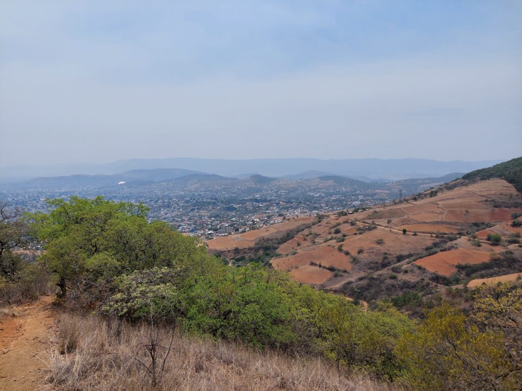
After about five minutes I got to a bench with a sign next to it, overlooking a nice view of some hills, and a little bit of the city. I wasn’t sure if that was it, and since the trail kept going I decided to keep following it. After about another five minutes I got to the actual viewpoint. I climbed a green tower, got up the stairs and finally had a nice clear view of the surrounding areas. I could see some hills, the city, and the entrance to the park.
It was a nice place to be in, and I was there for several minutes before I went down the stairs. Here too, I saw another sign about Ejido Donají. There was a split in the road, and it clearly led elsewhere, but I had no idea where, and at that point I also had no desire to try and find out.
Instead, I walked over back to the starting point of the hike, then to the entrance of the park, and from there back along the dirt road until I got to the bus terminal, where I waited for the bus back to the city. It was confusing to get to the park, it cost more than it should’ve, and I nearly gave up on it. The views weren’t amazing, I could’ve even said it was a good workout, and overall I felt like it was a shame. I wasn’t even sure that I got to where I wanted to be. Maybe, if the way over there was more simple than I would have felt better about the whole thing, but it just wasn’t satisfying.