Piedra del Zope, Atitlán Nature Reserve, Camino a Tierra Linda
Without any stops along the way, I left Cobán and went to Guatemala City. While I visited a few attractions in the city, none of them felt special enough. My time there was pretty mediocre, and I didn’t have much to say about it. And when I’ve done everything that I wanted to do, I left the city and made my way to Lake Atitlán and the city of Panajachel. Along the way there were some really nice views, which I enjoyed quite a bit.
After resting for a little, I decided to do Piedra del Zope, which the internet mentioned as an easy hike. After walking around the city streets for a little bit, getting confused, and asking how to get to the trail, I made it to an art gallery (which was closed), with a dirt trail next to it. It looked like it could be the right trail, although it wasn’t marked on Google Maps.
I started going up the trail, and quickly disappeared among the trees. The trail was a bit muddy and slippery in some parts, but it wasn’t a real problem. I started to build up a bit of a sweat and my breathing became heavier as I went up, and I wondered if it’s just the incline, or if it’s simply because I haven’t had a good hike in a while.
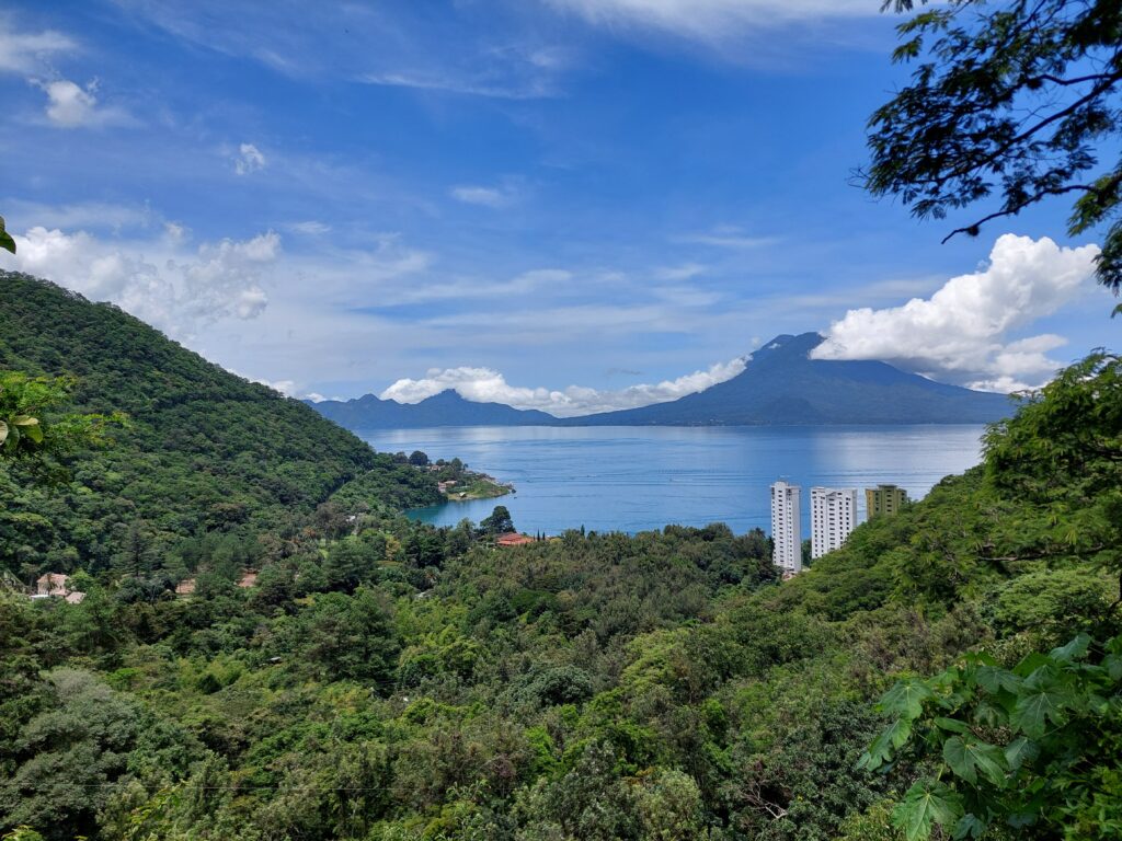
After some time had passed, there were some gaps in the trees, and I had nice views of the lake, the cities and towns around it, as well as some of the mountains and volcanoes. It didn’t take much effort or time to be able to see those views. I didn’t look at the map while going up, as it was a single trail, and there were some painted red arrows marking the way, although it felt a bit unnecessary. While I didn’t know exactly how long it will take to get to the end, I figured there will be a sign of sorts telling me I’m in the right place. But the trail kept going up, and so did I.
Going past the views and back into the thick of the forest up on the mountain, there were occasional splits in the road, which made me feel like it wouldn’t be difficult to wander off and get lost in there. Following the arrows, I kept going up along what I believed to be the main road. At some point I saw a man coming down the path, holding a large heavy sack over his head. A little while later I encountered a deaf man, and after showing him on Google Maps where I’m trying to go, he used his hands to try and explain to me how to go. I thanked the man, and kept going along the trail.
I kept going up, wondering why it’s taking so long, and what views I will actually get to see at the end. I passed by a few streams, and more muddy sections, before the road started to go down. The arrows were still pointing the way, but at that point an eerie feeling started to creep up on me, as if I’m not really supposed to be there. But I was curious, and kept going. This unusual feeling got stronger, and I thought to myself I need to turn around. A few minutes later I got to a fallen tree which more or less marked the end of the road for me. While I could technically keep going, I had no idea where to go. There was no clear trail, and no arrows to follow. Adding to the worry in my head, it was time to call it quits and go back.
For a while, nothing special happened, as I followed the path back. It wasn’t supposed to take very long, and I expected to start my descent without any issues. However, those splits in the road that I spotted earlier in the day proved to be a source of worry. I looked around after every split in the road, knowing that if I can spot the arrows it means that I’m on the right path and have nothing to worry about.
And then the arrows were gone. For several minutes, I didn’t see anything to point the way, and then I got to a section I was pretty confident I haven’t been to. Google Maps didn’t have any marked paths on the mountain, so I had no clear idea of where I am or where to go. Trying to go back to the last arrow I saw, I found myself facing yet another split in the road, and at that point I knew I got lost.
I was by myself, on a mountain, with no one else in sight, and no idea what to do. Still, it was early in the way, there was internet connection, and my smartphone wasn’t running low on battery. After some time had passed, during which I tried not to panic, I finally had enough sense in my head to use Maps.Me. It took a minute to download the map for Guatemala, but then I was able to take a look and figure out where I am. Although I was in an unmarked section, a marked trail wasn’t too far from me, and I headed over there quickly.
I had the app on display for quite some time, following the trail carefully. Steadily, I was going down, which was a good sign. After passing a couple more splits on the road, I started to feel pretty confident, and put the smartphone back in my pocket. As long as I was going down, I didn’t need to look at the map.
It was certainly a different road, which I haven’t been to, and I had somewhat different views to look at, although it was a bit difficult to appreciate it due to nervousness. Down and down I went, and after a while I could hear the urban noises louder and louder. Some more time passed by, and I saw a couple of structures, which I could easily get to. From there, it took me a few more minutes to get to the main road, and I didn’t need to worry anymore. All that was left to do was to follow that road back to the hostel, just as the rain started.
After getting some rest, I decided to try again. I asked several people along the way how to get to Piedra del Zope, and they all directed me to the very same trail that I was at already. Cautious, I started to climb up, wondering if this is actually the trail I was looking for and if I’ll get to the viewpoint. With every step, I made sure I knew how to get back, so that I wouldn’t get lost again.
At some point there was a split in the road, which I was sure I didn’t take on my first go, and so I went along with it. It was leveled for a while, and had the occasional view of Lake Atitlán. Then It started to go back, leveled again, and then started to go down. Looking at the map on my smartphone more often this time, I also noticed I’m getting further away from the point marked on Google Maps, so I decided to go back to the original split in the road, which I managed to do without any problems.
I was back on the main road, following the arrows and checking the smartphone. I wasn’t quite sure I’m heading in the right direction, and just as I was thinking it might be time to give up and go back safely, I noticed an arrow pointing away from the main road. I couldn’t remember if I followed it on my first go, or if I missed it and just followed the main road, but the option was enough to excite me.
I took this side trail, going up and up, and the smartphone seemed to think it is more or less the right direction. After some climbing, I got to a very large rock, which I somehow recognized as a waypoint I’ve been to already the other day. I was going along exactly the same path. I went up a little bit more, and got to the same gap in the trees where I stopped for a little rest before. It was close to the waypoint on Google Maps, but not quite there, and the trail kept going up, the arrows pointing the way further.
Keeping a close eye on the map, I followed the trail, all the way to a split in the road. The arrows were pointing left, which is where I got lost. On the right, there was a faded “no” marked on a tree, but according to the map that’s where I needed to go. It was a few minutes of walking along a narrow and a bit slippery path, and then up a leafy side path, but eventually I managed to get to the point that was marked on Google Maps as Piedra del Zope. However, it was not a viewpoint. Without much to do, I went back down to the proper viewpoint, and after a few moments of rest I made my way easily back down.
When the rain stopped and it was a sunny day out, I headed over to Atitlán Nature Reserve, which was a bit of a walk from the hostel. About half way there, where I went from the main road to a dirt road, there were quite a few people standing and waiting. Due to a storm from the previous day, a utility pole fell down and knocked a couple of trees with it, so the road was blocked. There were people working there already, trying to clear the road and let everyone pass.
After about half an hour of waiting, I was told I could go in, even though the road was not clear, I just had to be a bit careful. As the place also had a restaurant, accommodations, and a private beach, the starting point wasn’t by the fallen utility pole. I had to walk a little bit further before I got to the visitor center, where I bought a ticket before I was able to start exploring the area.
Since it was one of the attraction points of the nature reserve, my first stop was the butterfly sanctuary, which was a couple of minutes away from the visitor center. It was a small geodome enclosure, where many different butterflies roamed free, flying all around without being bothered by any visitors. There were many pretty flowers and colorful plants in there, which were another attractive points (not to mention that with a smartphone it was much easier to take photos of the flower than of the butterflies). For such a small area, I was there for longer than I normally would have, as I enjoyed it quite a bit, but eventually I followed the trail all the way to the beginning and exited the dome.
Nearby, I saw a sign that leads to the lake, but I was more interested in doing the hiking trail in the reserve. Without a map, I went back to the visitor center, and from there I wandered around the place until I saw a sign leading to a trail. However, as I started going up the trail, it felt a bit neglected, and I wasn’t entirely sure that it’s a trial I should follow. And then there were more signs, although they were pointing down the trail, rather than up, suggesting I somehow approached it from the other end.
I wasn’t sure if that was really the case, or if it even mattered, so I just kept going. The path was a bit muddy at parts, but it wasn’t enough to cause any problems. It was a nice walk in the forest, and as I was going higher up I hoped to have a nice view at the top, but I had no clue what’s waiting there, or how long it would take. At some point I came across a few other travelers, who were going down the path, but other than that it was a pretty quiet experience.
After some time had passed, the road got leveled for a little bit, and I spotted a nice viewpoint overlooking Lake Atitlán. The view that I could see from the spot was worth the short hike, especially on such a day with clear sky.
From the viewpoint the trail kept going up, and eventually there was a split in the road, leading to a zipline. While I had no intention to do it, it was another path that I could take, and since it didn’t take me much time or effort to get to the viewpoint, I wanted to explore more of this part of the reserve.
I climbed some stairs, and walked up the dirt trail, until not very long after I started I got to the end of the road. It was a nice enough viewpoint, although it was partially obstructed. There was no one else there at the time, although as I was making my way back down I came across a few people wearing helmets and harnesses on their way up. I kept going down, and short of another little detour to yet another viewpoint, the rest of the road was quiet and uneventful.
At the bottom of the path I came across a suspended bridge over a stream of flowing water, which I quickly crossed. As I was going down the path, I crossed another suspended bridge, and then the rush of water got a lot louder. I found myself right next to a waterfall, with yet another bridge which was positioned to provide a great view of the area. Below me, at the bottom of the waterfall, I could see a woman sitting on a nearby rock, although I failed to spot a path that goes there.
After admiring the waterfall for a few moments, I kept descending, crossing a few more bridges along the way. I crossed the last bridge, then went down a few more stairs, and found myself looking at some animals, which a nearby sign told me are a cold Coati. I never heard of them before, and although they seemed like nice creatures, ultimately they didn’t hold my interest for very long.
After going up another trail for a while, then back down, and to an observation point overlooking the coati, I felt like I’ve seen everything there was to see in Atitlán Nature Reserve and made my way back to Panajachel.
According to some online resources, the nature reserve could be a full day activity, but I was there for less than two hours. It was an absolutely incredible experience, better than any of the recent adventures I had, even though it wasn’t as long as I expected it to be. It felt like it would stick in my memory for quite a while, and for a good reason.
Another hike that I wanted to do while in Panajachel was Camino a Tierra Linda, which was supposed to have nice views along the way, and as far as I could tell, ended in a small down with the same name. Learning from the first hike, I made sure to ask several people along the way in order to make sure I really am on the right path and that I’m not getting lost again.
In order to get to the start of the trail, I walked across the city, passed the market, and kept going until I saw a bridge. Next to that bridge was a dirt path, which I needed to take. After several minutes of walking, there was an intersection in the road. I turned to the left and started the hike.
The road was twisty and and an incline, with practically no shade, so pretty quickly I started to build up sweat, and on top of that my breathing became heavier. It didn’t seem like a bigger challenge than Piedra del Zope, but it certainly felt like it at the time I made my way up. I slowed down a little, and stopped every now and then to catch my breath while looking around.
While there was no shade, there was a view, and quite a good one. There were green hills and mountains to the side, while the lake and the volcanoes were prominent either in front or behind me, depending on which section of the twisty road I was walking along. It was nice to be able to look around and actually see something, as opposed to being in the thick of the woods, even though it was more difficult than I expected it to be.
After some time had passed, the road started to level, and I got to the end of the road. I still kept going, until I reached a church under construction which on Google Maps seemed to be more or less in the middle of the small town, and sent down to rest for a few moments before starting to make my way back.
Unfortunately, while getting back to the trail a couple of seemingly innocent dogs jumped at me, and instinctively I ran away, screaming and trying to get them off me. Luckily, there was another small construction site where I was, and a couple of other buildings, so a few of the locals quickly came to my aid.
Although they seemed to be mildly amused by my reaction, they told me those dogs are dangerous, and one of the people there gave me a thick branch of wood to defend myself in case they come up. I was also advised to pick up a few rocks, just in case. I thanked the people, and cautiously made my way down the path, until I was sure there were no more dogs close by. As I didn’t get injured, I managed to calm back down pretty quickly, and the nice view I had to look at helped a little bit as well. Soon enough, I was back near the bridge, and from there it was an easy walk all the way back to the hostel.