Lake Churup, Lake Churupita, Lake Llaca
I made the mistake of thinking that Lake Shallap would be better to start with in Pitec, due to the altitude, and after that I headed to the far more popular Lake Churup. In hindsight, I should have done it the other way around.
I rested in the hostel for a bit, and then headed back to Pitec, this time for Churup. The dirt trail was at a noticeable angle, but I wouldn’t have called it steep. On both sides of the trail were white stones, and behind them were grassy hills. Just like with Shallap, the trail to Churup started with great views that got steadily better. I had views all around me- Hills, forests, cliffs, and mountains (a few of them covered in snow), gorgeous and gradually changing the further up the trail I went.
It was a fairly easy road, with a few stairs and a couple of rocks to pass. I took a couple of short breaks along the way, but that first section was pretty easy. It ended at the checkpoint area, where I was asked to pay and simply showed my monthly pass. The man who took it ripped a part of it, although he assured me I can still use any of the lakes at Huascarán National Park. I took another short break there before I moved on.
The white stones were no more and the dirt trail kept going up. There were a few stairs along the way, and some rocks to climb, and whenever I looked back I could see a bit more of the scene below me and beyond the horizon. I also managed to catch up with more of the people that were on the same colectivo as me, and we were overtaking each other as we got higher up.
I passed a rest area or two, and as I looked at the map it seemed my pace was a lot better than I thought it would be. I also noticed that I was getting closer to the more challenging part of the trail, which was supposed to have some ropes. It didn’t take long to get to that part, In reality those ropes were more like rubber tubes wrapped around metal chains. It added some excitement to the whole thing, and I quite enjoyed it.
It wasn’t a difficult path, and I quickly got past it. After a bit more walking, I got to the second section of the path that involved ropes, and this one was a bit more tricky and difficult. It was also at a steeper angle, which made me breathe a bit more heavily.
It took some effort, but I managed to clear the second section as well and could go back walking and climbing some rocks. The higher I went, the more rocks seemed to be there. The road wasn’t very clear at a few spots, and I waited for other people to figure out the way up. With this challenge, came different views, and as I caught my breath I also used the time to take in that view.
I looked at the map again and saw I’m very close to the end of the trail, and within a couple of minutes I was there. Due to the layout of the rocks around it and the angle of my climb, I saw the sign for Lake Churup before I saw the lake itself. When I did see the lake, the first thought that came to my mind was: “It’s a nice lake, but not spectacular”.
It was big, with a deep color which I liked, and surrounded by rocks and vegetation. But just like with Wilcacocha and Shallap, I found the view around Lake Churup a lot better than the lake itself. The lake on its own wasn’t all that interesting to me.
It took me a bit more than two hours to get there, and as I sat down on one of the rocks to rest for a bit I wondered how that happened. It was like all of a sudden someone changed that difficult setting to “very easy” and made me feel like superman.
And since I did get there early, I had plenty of time left and decided to challenge myself further by going to the smaller Lake Churupita. First, I had to figure out how to actually get there, because while on the map it seemed pretty straightforward, I did find myself a bit confused. There was a sign just by Churup that directed me to Churupita, but it seemed to point out to a very muddy and watery section that didn’t lead anywhere. The other option was to try and climb a cliff with a steady stream of water.
I stood there for a couple of minutes before I decided to go for the muddy area, thinking that it would be easier even if it gets to a dead-end. I used my trekking poles to help me navigate that section and try to find hard surfaces that I could rest my feet on. It took a few careful minutes, but eventually I did get past it, and when I did I was glad to see there actually was a solid trail that went into the woods around Lake Churup.
I looked at the map again, confirmed that I’m heading in the right direction, and headed in. It was a nice break from the rocky and mountainous terrain, and I could almost feel like I’m in a different place. There were quite a few gaps between the trees, so even there I could see both the lake and the surrounding area. Around that time an Austrian couple who was on the colectivo with me managed to catch up, and on that narrow road we were more or less walking together.
I headed up the trail, and formed a bit of a gap up until the road was cut off by a near vertical rock. I could see the trail on the other side of the rock, and another below it, which seemed to pass through a tree and wasn’t ideal. I stood there, confused, trying to look around for other options, but none were found.
Since my day bag wasn’t designed for hikes and moved around a bit, I felt it was best to temporarily get rid of it. I put it on the ground, along with the trekking poles, and holding on as tight as I could, I made my way quickly past the rock, almost slipping down. As I more or less dropped on the other side of the trail, I tried to see if it wouldn’t be easier through the lower trail, but it didn’t seem like it. The couple behind me managed to catch up again at that point, and for a moment also got confused. It didn’t take them long to figure it out, and the walk through the trees resumed as if nothing happened.
The road started to clear up, and soon I was out of the woods. The road was barely noticeable at that point, and I had to navigate between the rocks and try and find it. As I climbed up, I could see more and more of Lake Churup behind me, and everything else further down. I stopped at a few points to enjoy the view and catch my breath.
I knew I was getting closer, but the terrain made me question how long it would actually take. Then I noticed someone coming down. Since I was on the first colectivo to leave Huaraz that day, and I didn’t see him on it, it was quite a surprise. When he got closer I asked him how long it would take to get to the lake, and he wasn’t quite sure. He struggled a bit with trying to explain things in English, and eventually said I already passed most of the way, and that when I’ll get very close I’ll just be able to tell.
With that somewhat vague and mysterious conclusion he took off back to the main lake and I kept climbing. Just like the man said, it didn’t take long before I saw the signs- stones piled on top of each other, clearly made by other people who visited the lake before.
And then I saw Lake Churupita. It was small, nice, with great views around it, and overlooked Lake Churup. It was a bit over an hour to get there, and was definitely worth the extra effort.
I would have stayed to rest there, but unfortunately there was some light rain that made it annoying so after a few minutes I started my way back, and so did the Austrian couple. They overtook me at some point going down, then I overtook them, and after they stopped for a break I did not see them again.
When I got back to the near vertical rock, I could not get over it in the same way I did earlier on. I decided to go for the lower trail and find a way through, as I was about to do so, I saw another traveler head to Churupita facing the same problem, and shouted from below that she needs to put her trekking poles in her backpack, before moving forward.
While she did so, I managed to navigate through the branches of the trees and climb back up the other side. I grabbed my own bag and trekking poles, and waited to see that the traveler managed to go past the rock safely before I made my way back to Lake Churup, where I noticed quite a few more people.
I took a short break there, and then a proper break for lunch after I went down the ropes. After that, I went pretty much the entire way down without stopping, admiring the views once more.
Taking the same colectivo that goes to Pitec, instead of leaving with everyone else the driver took me to the starting point of the trail to Lake Llaca. He gave me a short explanation on how to start it, asked me for an estimation for when I’ll finish, and then took off, leaving me on my own. For the first fifteen minutes or so, I walked down a dirt road that was made for vehicles, as apparently it is possible to drive almost all the way up to the lake. I smiled to myself as I walked along, looking around at the beautiful views.
When I passed the curve in the road which was mentioned by the colectivo driver, marked by a tree, I turned off the driving road and into the walking trail. It was a bit rocky, had a few improvised stairs, and some plants. This road had more on an angle than the driving road, and my breathing got heavier as a result. There was a brief leveled section, and then I kept going up at an angle.
After a little while, I found myself back on the driving road. At that point I also thought my estimation for when I’ll be back was a bit optimistic, and so I rushed it a bit, hoping to give myself more time on the way back. For the very same reason, I told myself I shouldn’t take many pictures on the way to the lake, although that thought didn’t prevail for too long.
I kept going up along the road, which had a couple of turns, smiling every time a new part of the scenery revealed itself in front of my eyes. Then, once more, I stood in front of a locked gate. At that point I didn’t think too much of it and simply made my way around it (not to mention that there was no one to pick me up if I wanted to go back) and kept going.
I stopped for a short break near a small river, and then carried on. I slowed down for a moment when there was a noticeable incline, but once the road more or less leveled I rushed it once more, all the way to where there was another split in the road and I turned to the walking trail once more.
Just like on the road to Lake Shallap, on this road as well I saw some cows. The first section of this trail was a fairly simple dirt road with a few dips in it, which didn’t pose any challenge. There was some grass around as well, and of course, great views all around.
Then the road became more sandy at parts, with more rocks, and I navigated around them rather quickly. At some point in that section I also noticed a blue pipe of some kind, which led the way for quite a long time. It was particularly useful when the sandy and rock road gradually shifted into more rocks, and then a river. I placed myself on the right side of the river, along with the blue pipe.
The road went down and up a few times before setting as a steady and low incline. Then I saw a small pond in the middle of the road, with some horses next to it. That was also the point where I had to jump across the river to the other side, as the trail on the right led to a dead-end.
In addition to that, when I looked at the time I wasn’t sure I’d be able to make it. In order to avoid the stress I had at the trail of Lake Shallap, I set myself a deadline to reach the end of the trail, thinking that at the very least I had a really nice time walking in nature.
I kept going, trying to rush myself whenever I felt it was possible, covering ground as the rocky road turned into a grassy and muddy road, which required slow and careful navigation at a few sections.
I managed to cover them as well, although my worry about making it didn’t let go until I saw a small building. At first I thought it was what was marked in Maps.Me as “Refugio” and felt quite cheered, but then I actually looked at the map and saw I was still some distance away from it.
When I looked around (and up) I saw one big sign, which I felt had to be the sign for the lake, and a small sign, which I assumed was pointing the way. With a rush of excitement. knowing that I’ll just about meet the deadline, I started the final push for the lake.
At that point, there was no clear road, so I had to make my own way, trying to take a shortcut toward the small sign. The sign disappeared for a couple of minutes as I climbed up a steep rocky section, momentarily making me wonder if I just imagined it, but I soon found it again.
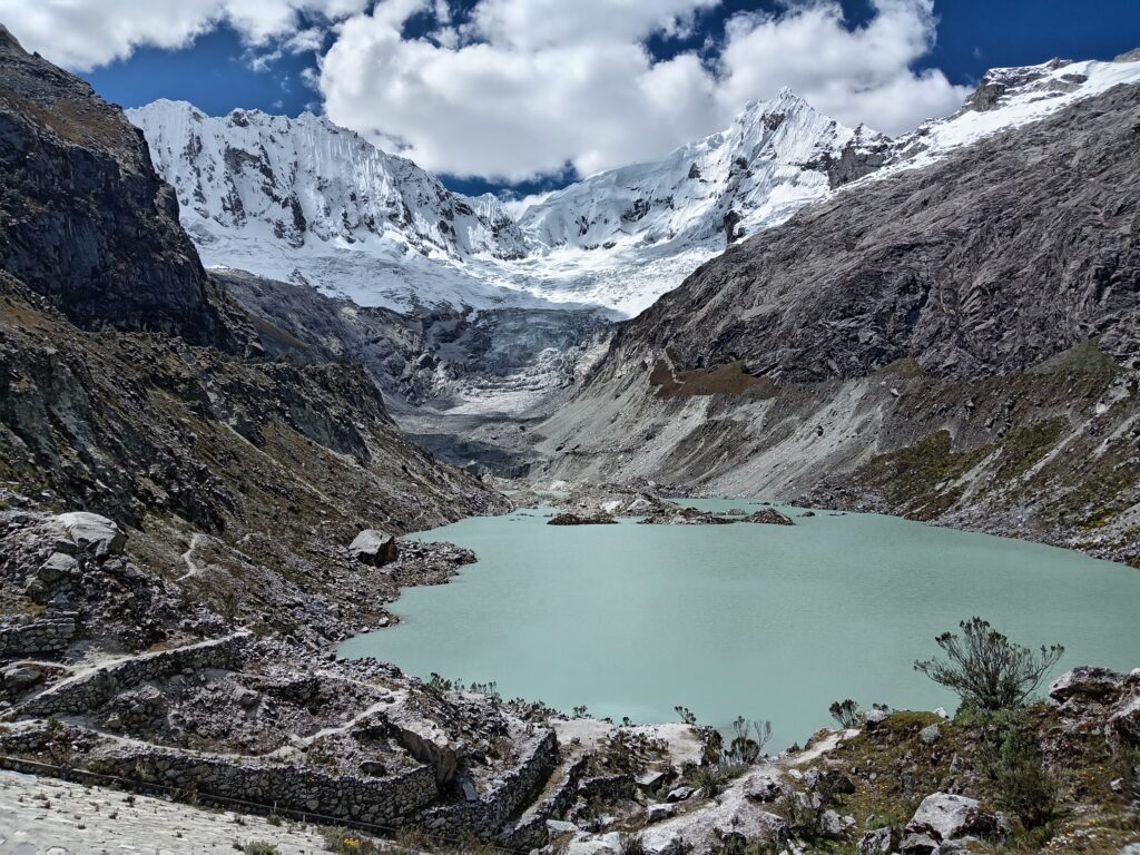
I got to it, found myself on an actual road, crossed another stream, and then walked along the side of a mountain pretty happily. I was actually a few minutes behind the deadline I set myself, but it was too late to go back. When I had the chance, I took another steep shortcut, walked a few more steps, and I was right by the big sign that told me I reached my destination.
Lake Llaca, as well as the view around it, was the best one I’ve seen so far in Huaraz. While it wasn’t the biggest, it had a unique color that I loved, and snowy mountains behind it added to the dramatic view.
I got there about five minutes after my deadline, and so I couldn’t stay for too long. I gave myself about ten minutes to rest and enjoy as much of the view as I could while eating a little snack and drinking some water. If I had given the driver a longer estimation for my return, I could’ve stayed for a bit more and not rush myself.
On the way back, as passed by the “refugio”, which turned out to be a camping area. A nice man who I assumed was an employee greeted me, and after saying hello I had to find my way back down to the small building I’ve seen earlier and to a more leveled ground. It didn’t take long, and after I passed a few cows and got closer to the river, I stopped for a lunch break. This one, too, wasn’t long, but I covered enough ground so I could actually sit down without worrying.
After lunch I kept going down the river, jumped back to the other side as the same place near the horses, and didn’t stop again until I reached the driving road. I took another quickie break there, which was the last one along the trail.
A bit before I got to the locked gate I saw a man going up. He said something I really didn’t understand, since he didn’t bother slowing down. I told him I don’t know (unsure what it is that I didn’t know) and went on my way. The only words I did understand were “prohibido” and “ingreso”, which when I put them together in Google Translate meant “entry prohibited”. I was confused, since I was clearly not the only person at the lake, and didn’t give it too much thought.
I ended up at the starting point of the trail right before the agreed upon deadline, and waited for the colectivo to come and pick me up. Out of the three Pitec hikes, for me this was the best one.
After Pitec, I had to book an organized bus to get to the very popular Lake 69, which was interesting, not very challenging, and was beautiful at the end. The views, while good, were a bit underwhelming in comparison to the other hikes I’ve done, but since my main reason to go there was to go higher in altitude, I didn’t mind it all that much. On the long way down, I started to wonder if I got a bit tired of the lakes, and if it was time for something different.