Kohekohe Loop Track, Paekākāriki Escarpment Track
In order to get from the south island of New Zealand to the north island I went on board the ferry from Picton to Wellington. It was a pretty comfortable ride, although a bit boring. While it was possible to sit by the window and look at the view, there wasn’t always much of a view to look at, and when I made my way up to the top viewing deck there was a very strong wind and I headed back down pretty quickly.
After getting to Wellington it didn’t take long before I headed out, to the town of Paekākāriki and the Escarpment Track. As the trains didn’t operate at the time I was there, so instead replacement buses were available. Thankfully, the one that I needed left from the train station, so it was pretty easy to find. As it was an express bus there weren’t many stops along the way, and soon enough I was in Paekākāriki. It took a little while to figure out where in town I was dropped off and how to get to the actual trail.
After crossing the train tracks I walked along a paved road for a while until I saw a sign directing me to a dirt trail shaded by trees. It was pretty comfortable and pleasant, with some colors giving the path a pop of color, but not much else. A few uninteresting minutes passed by and I found myself in front of a gate which was marked as the beginning of the Escarpment Track.
I closed the gate behind me, went down some stairs, came across a warning sign regarding the challenges of the track, and started walking. A small section of the trail was a bit muddy, but I got past it quickly and didn’t think much of it. I went along the narrow path, at times under the sun and at times under the trees, without too much to look at. That is, until I got to a split in the road. The main trail seemed to keep going straight (and down), but according to the sign there was a side trail heading toward the Kohekohe Loop. After consulting with another traveler who passed by to make sure that the main path is heading to where I thought it was heading, I took the side trail and made my way up along the loop.
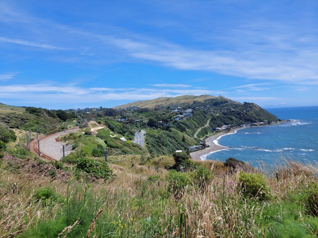
At first I was under the trees, shaded and with no view to look at, but a little while later I was under the sun and getting above the trees, so I finally had my first look at the view that will accompany me for the rest of the day. The coastal view is something I almost always enjoy, and this case was no different. I got to a bench, which was a nice stopping point, but I just kept going, wondering if the view would be better at the top and how long it would actually take to get there.
As I was going up, I was back under the trees for a while before I got to another exposed section where I had a slightly different view of the coast. The road was alternating between sun shade, views and trees, and I’m not sure if there was a specific view point at the top that I needed to get to, but if there was one then I might have missed it. At some point I started going down, coming across a couple more people along the day before getting back to the start of the loop.
With that distraction out of the way, I resumed my walk along the main path, going down for a while (right by the train tracks at some point) before starting to go back up. I was surprised by the amount of people I saw along the way, and on such a narrow path (which so far seemed to be a standard for New Zealand) it caused people to slow down, and sometimes stand still, while facing traffic coming from the other direction. It also meant that if I wanted to overtake someone, which happened quite a few times, I needed to wait for a wider point in the path, like a rest area with a bench, where it was possible to move ahead quickly without taking unnecessary risks.
Whenever I was emerging from under the trees into the sunny day I was greeted by the coastal views that kept changing slightly as I walked along (and the mountains behind and ahead of me added more interesting to the scenery). In addition to the sun, there was also the wind, blowing all around without stopping. By that point I built up a bit of sweat, and the wind helped to cool me down.
Then there were some stairs. While going down those stairs, I thought I read somewhere that those stairs should be near the end of the trail, and I thought that if those are the stairs I’m thinking of, I got to the end earlier than I thought I would. And then I remembered reading that there are two suspended bridges along the track, and I haven’t crossed them yet. Those thoughts made me feel quite confused. I had no idea where I was along the trail and it’s been quite a while since I saw any signs.
So I just kept going, at times stuck behind other people until I could overtake them, and just as I was considering stopping for a lunch break I finally saw the first of the two suspended bridges. While there were a couple of benches nearby, with a great view, they were occupied by other people, so instead of sitting down I just kept going.
The bridge, just like the rest of the track, was narrow. On top of it, there was a warning sign stating that there should be no more than five people on that bridge at one time. The people on the track however, were a bit more cautious, and one or two people crossed the bridge before another person went along. When it was my turn to cross, I was a bit cautious too. The wind was blowing hard and the bridge was swinging quite a bit. I tried to focus on maintaining my balance while crossing, which was a bit of a challenge.
After I crossed the bridge it was time to go up some stairs rather than down, and then the road was level for a while, with tall grass on both sides of the path that at times blocked the view. It was a pretty comfortable section, and even though I spotted a couple more benches along the way, they were either occupied or without much of a view to look at.
Then I went down some stairs, and across the second suspended bridge, which was just as rocky and windy as the first one. I crossed it quickly, went up some more stairs, and then down, for quite a while. At this point, I gave up on finding a spot to sit down. Instead, I planned to just eat while walking and just get to the end.
I went down one set of stairs after the other, and eventually down to the bottom. From there, it was a fairly easy walk with a gradual decline, so it wasn’t too difficult at any point. In fact, there was barely any difficulty to the entire track. As soon as I could, I was finally able to eat something while looking at the view around me.
Eventually I made my way back to ground level, and once more walked along the train tracks of Pukerua Bay. It was a flat and boring road without much to look at, which ended in a locked gate. Luckily, there was another traveler right behind me who told me how to unlock it. A few minutes later I was at the train station, but as there were no trains that day, I needed to figure out where to take the bus from. The traveler behind me had the same issue, although we were going in different directions, we were both looking for the bus stop.
Due to a misunderstanding, I found myself waiting for the wrong bus for a while before I managed to get myself to the correct side of the road, where after waiting for a bit the bus back to Wellington showed up. That, to me, was the biggest challenge of the track, which was otherwise easier than I expected, and quite beautiful throughout.