Not very satisfied with my visit to Hahoe Folk Village and eager to explore more of South Korea’s nature, I moved on to Daegu. As far as I could understand, there are quite a few scenic places in there which are worth checking out, and even a national park, although it’s a bit far from the city itself.
My first stop in Daegu was Apsan Park, where I plan to climb at least one of the 3 mountains in the area. There was a cable car that could take me all the way to the top, but I prefer to climb on foot. The bus stop was a few minutes away from the cable car station, and the start of the trail in Apsan Park, so I had to walk for a little bit before getting to the starting point. Although the road was going uphill, it was paved and very easy to walk on, so it wasn’t much of an issue.
After a couple of minutes I came across an unexpected stop- Nakdong River Victory Memorial Hall. Thinking back to all I learned about the war back when I was in Seoul I decided to go in and learn about more. I took one of the leaflet guides from the entrance (didn’t see anyone there when I walked in) and followed the signs, starting at the first floor. Other than a few names and titles in English, pretty much all the signs were in Korean, so I relied on the leaflet to provide me with some information.
The first floor of the memorial hall was about the background for the Korean War, as well as some battle scenes from the Nakdong river, explaining the importance of it and the battles that went on in that area. The second floor was about Korea’s rebound, talking about how the war began and the hopes for the future. On that floor there were some relics and guns on display, along with a memorial hall with some sculptures in it. The third floor had different VR experience options, and that is where I finally saw some staff members. I chose the Black Eagle VR Experience, flying with the Black Eagles aerobatic team. For a few minutes, I could pretend to be in one of the airplanes and do some aerobatic maneuvers in the skies over Daegu.
I exited the building and took a short walk around the garden where they had some tanks and planes on display. After that, I resumed on the way to the cable car station, and the base of the hike up Apsan Mountain. When I got to the station, I looked at the map, used google translate, and after a few minutes, I picked a trail and started walking.
While the road was paved, it was uphill, so it wasn’t long before my breaths became heavier. It made me wonder if I can actually make it to the top of the mountain, or if I’ll have to turn back at some point along the way. I sat down for a little while at the first rest stop I saw, which for some reason had a clock and mirror, and when I felt better I resumed my climb.
The paved road ended and was replaced by a dirt road, although it wasn’t so steep anymore. Going up a mountain, I expected it to be uphill all the way, but it was a lot easier to climb Apsan after clearing out the first part. Every now and then I’d see a sign or an improvised rail that let me know I’m going in the right direction, as well as other hikers that were coming back down from the mountain. As I kept climbing I could hear the birds singing and the wind brushing the treetops, but other than that it was pretty quiet. Being in the thick of the forest, there wasn’t much of a view to look at, but I was hoping there would be a great pay off when I’ll get to the top of Apsan Mountain.
At some point the dirt road was replaced by wooden stairs, and I was wondering if it would be the same painful climb I had up to Ulsanbawi Rock. Despite that, I kept going up, stopping to rest every now and then. The road was alternating between dirt trail and stairs, and I stopped every now and then for a little break.
After one more steep set of stairs I came across a flat ground and a road that split in different directions. The sign that was placed there told me I can go to either Sanseongsan Mountain or Apsan Mountain. I chose the latter as it was my original plan and I didn’t think I’ll have enough time to visit both of them. Being on relatively flat ground, I thought I needed to be pretty close to the top at this point. I could see the sky again, although there were still trees and shrubs blocking the view as I walked along the trail.
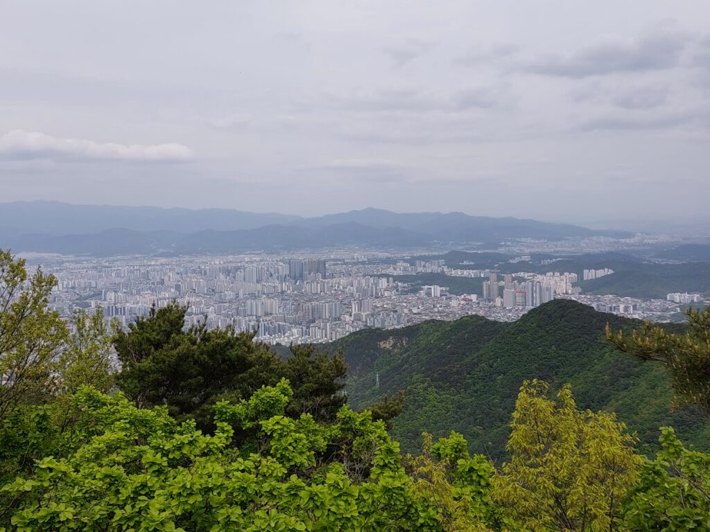
A few minutes later there was a bit of an incline and I had to climb a few rocks. At the top there was a little pavilion where I could sit and rest while finally being able to take in the view of Apsan Park for the first time. There was green all over the place, trees spreading far and wide, and at the bottom, from both sides of the trail, there was the city and its many buildings. And as great as it was, I thought it felt a bit small to be considered the top of the mountain, not to mention there was no sign that pointed to the top station of the cable car.
The trail kept going, and so I kept walking on it, as it was alternating again between wooden stairs and a dirt path. Not too long after that, I climbed up a short set of stairs, and found myself at the peak of Mount Apsan, along with a few other people. The view was similar to the one I had from the pavilion down the road, but it was higher, and more open, so I could see more. There weren’t any benches around, so I just sat on the ground and rested there, taking a look at the view.
I didn’t think I’d have enough time to visit another mountain, but as I didn’t want to go back from the way I came I just kept going along the trail that was supposed to take me to Daedeoksan Mountain. The path was rocky, and even though it was going downhill this time it was still difficult to cross. It took me some time to get to another flat ground, and a short while later the road was splitting again.
Instead of going to Daedeoksan Mountain, I decided to make a turn and keep descending toward Wanggul Cave. I had no idea what it was, where it was, or what was the story behind it, but I was curious to find out and I thought it would be a nice stop on the way down. If it wasn’t for the improvised railings that popped up every now and then, I would’ve struggled to find the path. Going over rocks and tree roots, I had to be careful and make sure I didn’t slip.
Then there was a bridge, followed by descending stairs. I stopped at the top of the stairs briefly to take a look at the view, and then proceeded down until I reached the Wanggul Cave. I tried to translate the sign using Google Translate, and in broken English it told me the story of king Taejo Wang Geon who was hiding in the very cave after being defeated by Hyeon Hwon. According to the story, it was rumored that a spider covered the entrance to the Wanggul Cave with webs, so even though it was small, there was no way to tell if anyone was hiding there.
Taking a long inside the cave, it was indeed very small and not deep at all, it took merely a few steps before I touched the wall. Unimpressed by the cave, I moved on, going further and after a while I found myself in front of Anilsa Temple, which was built during the first year of the reign of King Gyeongsun, in the year 927 AD. The complex wasn’t particularly big, so after taking a quick look around I moved, going down on a paved road until I reached the flat ground, leaving the area in quite a different spot from where I started.