The first challenge I had when I looked into Gayasan was how to actually get there. The navigation maps didn’t work, and when I asked around I was told it might be better to rent a car than to get there with public transportation. After doing some research, I went over to Seobu Bus Terminal to verify that they do indeed have buses running all the way to Haeinsa Temple, and as far as I understood I could walk from there.
The ride itself was not as long as I thought it would, less than an hour and a half, but when I got off the bus I wasn’t really sure where to go from there. The few other people that were on the bus made their way toward the temple, but I didn’t feel like visiting it. There was also a town nearby, so I walked around for a little while, trying to figure out where I was and where to go. Eventually, after some more googling and looking around at the signs, I managed to figure out that Haeinsa Park is inside Gayasan National Park, and there is no entrance fee. All I had to do was to pick a route and start hiking. So I picked what according to one online source was a popular trail up to Sangwangbong Peak (at the height of 1430 meters).
So I went back to the bus stop, and from there I had to walk until I got to Haeinsa Temple and the beginning of the trail. From there I simply followed the sign, climbing up the mountain. The dirt trail was not challenging and I felt quite comfortable walking on it, especially as the angle wasn’t very steep. Once again, the urban noises started to fade away and were replaced by water flowing along the stream and bird callings. I was surrounded by trees, and for a while, there wasn’t much more to it, simply climbing up a path to the top of the mountain.
And then the dirt trail was replaced by stairs. By itself, that wasn’t very interesting, although my knees were certainly not looking forward to it. But after clearing a few of those stairs and looking around I noticed a sign that stopped me in my tracks. I wasn’t sure what it actually said, as the sign was in Korean, but the image they put there was worrying enough so that I used google translate, and the broken English on display told me there might be black bears in the area. I had no idea how real that danger might be, or how well the sign got translated, but it was enough for me to feel quite scared. From that point my progress up Sangwangbong Peak had slowed down. I’d stop every few steps to check if I can hear or see anything suspicious. Trying to be stealthy, I felt very aware of how much noise I make moving around. At that moment I really wished there were other people around. The road became steeper, but that didn’t really bother me, even if it did make the climb more difficult.
Although I kept telling myself that it’s probably fine and nothing is going to happen, I wasn’t able to relax until I finally saw another hiker on the trail. I quickly passed him and kept going up the stairs, still looking around every now and then, but not as often or anxiously as I did before. At that height, the city sounds were gone, although I could hear planes going over my head up in the skies, and the strong wind was quite loud too. I know I still have some distance to cover, but I was getting closer to Sangwangbong Peak. I climbed higher and higher, almost reaching the treetops with my hand, until eventually I got to a shallower dirt path which was easier to walk on. I had glimpses of the view from that spot, but it was still obscured by the trees and shrubs, making it very difficult to take a good look.
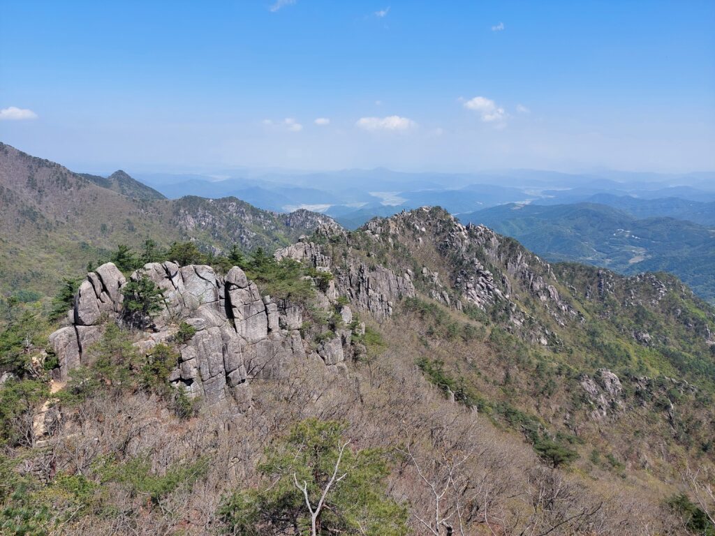
It didn’t take long before I reached another staircase, which was quite long and connected to a few other staircases via bridges. After clearing some of those stairs I also cleared the treetops, and finally got a good view for the first time that day. The rocks and trees I could see all around me created a very scenic picture. The wind was even stronger and colder up there, so I didn’t stay there for too long and just went on up the stairs, wondering how long I have left until I reach the top and what kind of view is waiting for me up there.
For a while, nothing interesting happened. I’d pause to look at the view for a moment and then keep going up, until I finally cleared the stairs and was on a flat dirt trail once more. There was a good view from there, but the sign informed me I’m still about 200 meters from the top. The problem was that the trail just ended. I tried to follow the direction of the sign, but it seemed there was nowhere to go, with either trees or rocks blocking the way. I was dumbfounded and unsure of what I should do. I just sat there for a while, looking around and thinking about my next step.
I thought about simply staying for a little while and waiting for someone else to come up, and maybe look for the path together, but I had no idea how long it would take. So I got up and decided to climb the rocks, hoping to see some kind of sign beyond them while at the same time being confident that there is a very unwise thing to do. I was both surprised and relieved when I spotted a sign and a staircase in the distance. I had to climb a few more rocks before I could notice a path that leads to said staircase.
After I managed to find my way down from the rocks to the trail the rest of the way to the top was fairly easy, a little dirt trail followed by one final sat of stairs, and then I was at the top, standing on Sangwangbong Peak and looking around on the clear view below me. As nice as it was, the climb wasn’t over just yet. Next to where I stood, there was another peak, Chilbulbong Peak. So I made my way over there, which took a few minutes but wasn’t much of a challenge. It was 3 meters higher, and although it didn’t sound like much to me, it certainly felt like a big difference in altitude. From that spot I also managed to see a little bit of the city as well. I sat there for a while, resting and feeling quite happy that I didn’t give up along the way. But the day was not over, and I still had to get down.
While I could’ve simply come back down the same I came up, I preferred to take a different route. From that one article I found earlier in the day I vaguely remembered a mention of a different exit point, and on the map I could see the road going down on the other side of the mountain. So I went on and started my descent, wondering what kind of view I’ll be able to see along the way.
There were more rocks to climb on, popping up every now and then between stairs, bridges, and dirt trails, but it was pretty clear where I should go. That is, until I reached a split in the road. There were two ways down, and I decided to challenge myself and pick the more difficult one. The first half of the trail was marked as “advanced” while the second half was marked as “expert”, and the trail I did so far was “intermediate”.
All along the way, I did not feel an increase in the difficulty of the trail, at least physically. There were less stairs and railings, and more rocks and trees, but I found that easier, and more enjoyable, than to go down an endless set of stairs. What was difficult for me, was the lack of markings along the way. Occasionally I would see some railings, some stairs, or a sign that would tell me I’m going in the right direction. That was more of a mental challenge for me, trying to figure out which way to go. As a result, I spent quite a lot of time going into one dead end after the other, and it took me a lot longer than it should have to go all the way down.
On the other hand, slowly descending from the Chilbulbong Peak, I got to see more views as they slowly and gradually disappeared among the trees, until eventually I was no longer able to see the sky. Along the way, I was wondering why I saw very few people along the trail, and if the trail was really as popular as I thought it was.
When I got down, I found myself in a very quiet area next to what turned out to be a camp site. Not really knowing where I am, or how to get back to my starting point, I asked one of the people who worked in the area (and I’m still not sure if it was an information desk or a check in point for the camping site), who explained to be with basic English that there are no buses from that point, and that I’ll have to take a taxi to the bus station. He was also very surprised to find out that I hiked all the way from Haeinsa Temple to Sangwangbong Peak and down to the campsite. He helped me call a taxi, and when it arrived I thanked him and drove off to the bus station in order to get back to the city. I enjoyed my day at Gayasan National Park, although it was a lot more confusing than it should have.