Grampians National Park
Taking a train and a bus, I left Melbourne and got to Halls Gap in a journey that took about four hours. Having no real knowledge of the area, I asked the hostel staff for recommendations. After seeing some kangaroos in the local park, I made my way toward the suggested route toward a place called “Pinnacle Lookout”.
On the way to the starting point of the trail, I noticed a sign to the local botanical garden, and as it wasn’t far away I decided to go see it. Very quickly I realized it wasn’t what I expected it to be. What I had in mind was similar to the botanic gardens in Melbourne, but instead the scenery was mostly green, without much variation to it. There were different trees in there, and different signs explaining about them, but as I was interested in reading them I felt the whole thing was a bit of a bust and quickly made my way out, this time heading toward the beginning of the trail to the Pinnacle without any more detours.
A few short minutes later, I was at the sign that marked the beginning of the trail to Pinnacle Lookout. A bit ahead of me there were a couple other hikers, but along the bendy road I quickly lost sight of them among the trees.
And just like that, I was back on familiar ground. The trees on either side blocked the view as I went up the path, climbing higher and higher. The noises of the town gradually faded away, giving room to the calls of birds. The thoughts shifted constantly in my head, while my eyes looked around. The further I got from the town, the easier and more freeing it felt to breathe.
The route to the top was not particularly challenging. The ever so dreadful stairs were present along the path, although they were not very steep. While it was not difficult to climb up, it still required a bit of effort, so every now and then I took a little break, especially, closer to the top, when I spotted a gap between the trees and had a little bit of a view. At some point I overtook the hikers I saw earlier in the day when they stopped for a break, while at other points they overtook me back. Other than that, the road was pretty empty and quiet for the most part, short of the birds and the flies.
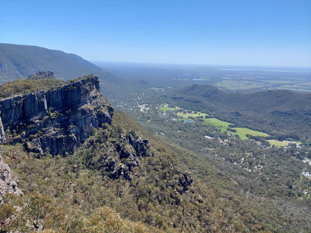
Closer to the Pinnacle, things started to change. There were more gaps between the trees, and more hikers appeared on the path. A short while after that, I finally reached Pinnacle Lookout. After waiting for the group that was there to clear the way, I took a look around me (as well as a couple of photos). The view from the top was nice, although I wouldn’t call it impressive. To me, the view was in the right proportion to the effort and time it took getting to the top. Not too challenging of a path, not too spectacular of a view.
I stuck around the Pinnacle for a little while, resting and enjoying the sun. It was a good place to just sit and relax, and I did just that.
Instead of going back down on the same path, I took a different path which I hoped would lead me to a place that was marked in the map as the “Grand Canyon”. While I was still pretty much in the same area, going down a different road resulted in different views, and I didn’t rush myself to get to the end.
Eventually I heard the flow of water, although I wasn’t sure where it came from. A few minutes later, I found myself looking at a thin stream of water going down some rocks. The marker on the map called it Bridal Veil Falls, but I thought that name was not very accurate considering the small scale of it.
On and on I went down the road, dealing with rocks, stairs, and dirt tracks. And all the time, the relentless flies were buzzing annoyingly around me. I came across more hikers on this road, some going up while others going down. Just as I wondered how long it would take me to get to this Grand Canyon, I saw a gate, and next to it a sign that said the way to the Grand Canyon is closed. There was a suggestion for another route to take, but I found myself quite confused by it. Without much of a choice, and with a bit of disappointment, I kept going down the path all the way to a car park, where I could sit and rest for a bit while having lunch.
Next to the car park there was another sign, pointing the way toward Turret Falls. It was still early in the day, and I wasn’t fully satisfied with what I’ve seen so far, so I decided to head over there before going back to town.
The walk was pretty easy and comfortable for the most part, twisting here and there, but with no serious challenge, with a slight incline and a welcome lack of stairs. The sound of the waterflow got gradually stronger, and I was sure it won’t be long before getting to the end. At some point I came across a couple of hikers who were making their way back from the waterfall to the car park.
A few minutes later I got to a bridge which was located pretty much over the waterfall. Seeing that there is more path to follow and as the view wasn’t so clear from where I stood, I kept walking. I came across what looked like a stone bench and finally got a view of the Turret Falls. While not particularly big, I found it better than Bridal Veil Falls. It was a fun little detour before going back to Halls Gap.
After I got back to the car park, I noticed another sign about the Grand Canyon and tried to follow it, got confused pretty quickly, and decided to give up on it. The path down to the town took a while, and along the way I made two more stops.
The first one was another short detour to Splitter Falls, which was a fun little walk that ended in a nice view. The second was Venus Baths, which was disappointing. Judging by the name alone, I expected an old bath house of sorts, but it seemed to be just a creek where people can soak and enjoy the cool water.
After a quick look at the area I kept walking, and without any more detours I finally made my way back to Halls Gap.