Baru Volcano National Park
The last hike I planned to do on this visit to Boquete was to the top of Baru volcano. While most people generally do the hike during the night in order to get to the top in time to see the sunrise, I decided to do it during the day. I valued my sleep and knew I’d need the energy in order to do (and enjoy) this hike, on top of not really caring about sunrise anyway.
I thought I’d do it all by myself, but then the day before I planned to hike three more backpackers to check into the accommodation, with the same mindset as me. Just like that, I had hiking partners, which made me feel safer.
Unfortunately, things went downhill from there. During the night, my smartphone fell and stopped working again. I didn’t want to let that ruin my ability to have fun, and so I still wanted to go ahead and hike. Early in the morning, before the sun came out, we were getting ready, and it turned out my hiking buddies were feeling sick and would stay in.
The rest of us went out, got a taxi, and headed to the entrance from the trail. There we were told the weather is really bad (and groups that wanted to hike during the night were not allowed to do it at all), with no views, and a strong recommendation to come back another day. Learning from previous experiences, I decided to listen to that recommendation and went back to town, while the other two went ahead to do the hike anyway (they did get a view at the top of the volcano, but only for a short time).
I waited a couple more days, during which I got myself a new smartphone, I was ready to give the hike of Baru volcano another go. This time, the weather was a lot better from the very beginning. After signing at the entrance (and paying online), as the sun was rising over the horizon, I was finally able to start the hike to the top of Panama.
The first part of the hike was during the end of the sunrise, which I was able to see at a couple of viewpoints along the way, and that was really the only interesting part about it. Knowing the trail is long, about 13.5 kilometers, and with a peak that sits over three thousand meters, I deliberately paced myself, once more, building on my experience from previous hikes. I walked a bit slower than I naturally do, hoping to minimize the effort and with the need to rest for a long time.
At half-hour intervals I had short breaks, about 2-3 minutes every time, to eat a little snack and drink water, keeping the energy level up and staying hydrated. I had only one longer break along the way, to eat my breakfast, but even that was probably less than ten minutes. As a result, even when I did eventually get to the top of Baru I didn’t feel all that tired.
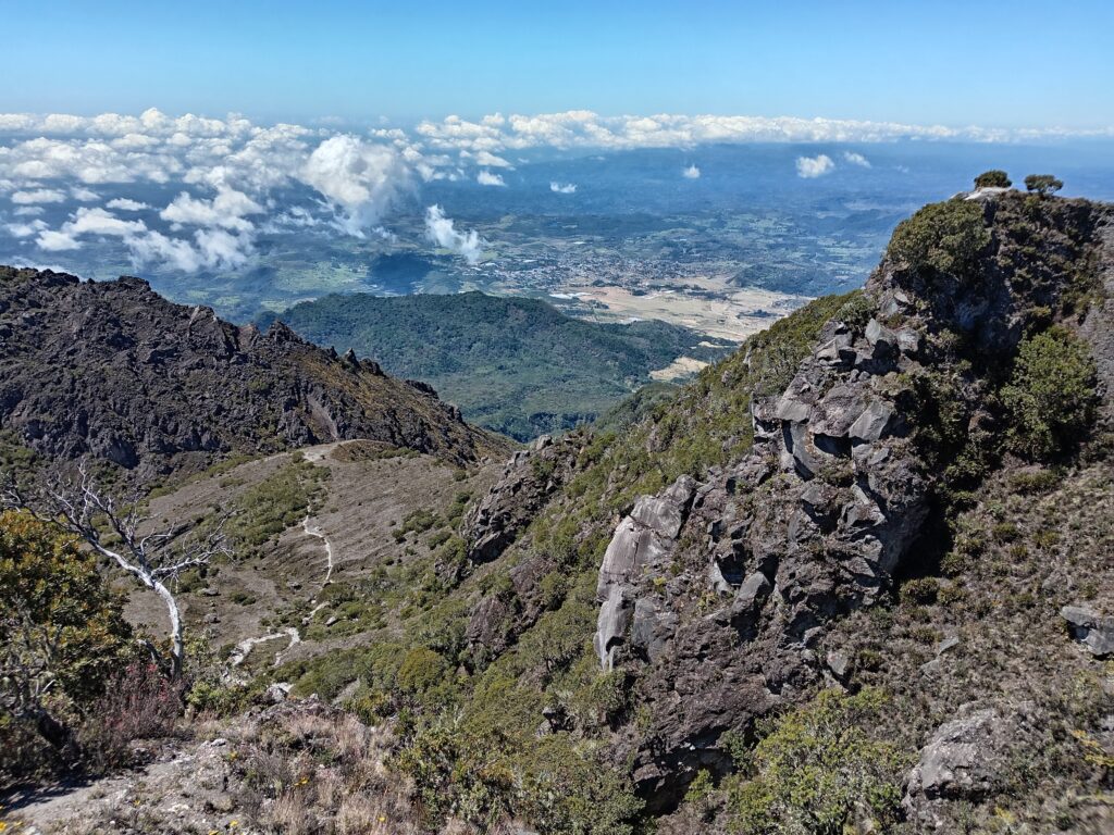
The terrain didn’t really change for the most part. There was one camping area relatively close to the beginning, and all the way to the second camping area (which looked like the main one), the trail was rocks and dirt pretty the whole way, and occasionally there was a gap in the side of the road that served as a viewpoint.
For me, the second part of the trail was marked by the traffic. I saw one car going down the trail and passing me on the way to the entrance. About ten minutes or so after that, I saw another one. And then a few more. I lost count of how many, but I think there were about five or six of them going down while I went up. There were also a couple of pickup trucks going up, full of workers, but they were the only ones I encountered.
Then I came across the hikers on foot, solo hikers, and small and large groups, all of which were making their way down at their own pace, without any time pressure. While most of them were strangers to me, one of those groups came out from the same accommodation that I stayed at, with some of them stopping to say hello and wish me good luck. The last spot that I’ve seen people going down from the top of the volcano was a bit before the second camping area.
When I got to that camping area, it was just in time to take another short break, and that was the final one before I got to the top. In that final section, the road was at a bit more of an incline at some parts, but not all challenging, but I was told it would be. It also opened up more, and there were more viewpoints along the way. I think it took me about forty-five minutes to get to what looked like an electrical substation of sorts. There were two viewpoints there, with binoculars, and I checked both of them.
Then it was time for the final section of the trail. I went up some stairs toward a viewpoint with a white cross, marking the top of Baru volcano and the end of the hike. That took a few minutes, and wasn’t really interesting, but just before I got to the very top I saw a split in the road, with another trail going down to what the sign referred to as “Los Llanos”. I stayed there for about a minute, quite confused and unsure where it leads to, whether it’s a viewpoint or something else, as I didn’t read or hear about it anywhere. Then a security guard came up behind me, and I asked him about it. He said this road takes about two and a half hours, and leads to “Volcán”, and it took me a little while to realize he is referring to a city by that name, not another volcano.
And so, I went on up the stairs all the way to the cross. There, at the top of Baru, I got the best view the mountain had to offer. I could see all around, all the way to Costa Rica according to the security guard, and it was beautiful from every single point. As impressive as it was, for some reason it didn’t feel as good as Piedra El Musgo. It was amazing, but I didn’t feel the need to stay on top of the volcano for long, especially (or perhaps because) the security guard there, which I did feel at El Musgo.
Since I didn’t feel tired, despite walking for five and a half hours, I was just about to start making my way down when the guard said goodbye and went back to the electrical station. Then, I was able to enjoy another big advantage of doing this hike during the day- I was at the summit all by myself.
About ten more minutes later, I made my way down the stairs and got to the split in the road, where I could take the road that the sign referred to as “Los Llanos” and the guard referred to as “Volcán”. I was quite excited for this one. Not only did it mean I didn’t have to go back exactly the way I came, which is far less interesting, but it was supposed to be a shorter trail as well (although it requires taking two different buses in order to go back to Boquete).
And so, I start descending. There were some improvised stairs, but for the most part in that part I was going along a dirt trail in and out of the forest. When I emerged from the woods, there was a relatively flat area to the side that served as an excellent viewpoint.
Since I couldn’t find myself on the navigation apps at that point, I relied on the wooden rails to show me the way. After a little bit more going down the improvised stairs, I made it to a point where I was able to find myself on the maps- I was at “the crater”, which was yet another camping area, and in my mind the best located one.
It took me less than half an hour to get there, and up until that point everything was fantastic. It was definitely a worthwhile detour. If only I stopped there. Instead, curiosity drew me onwards, toward the unknown.
Excited, optimistic, and still with plenty of energy, I continued on. For a little while without any clear markings, going along what was the most likely option for a trail, down some rocks along a windy path. And since the crater, everything was out in the out, which meant I had a great view the entire time.
Then there were more railings, something accompanied by stairs but for a big portion they just went over some rocks. While it was challenging, interesting, and very beautiful, somewhere along the way I started to get worried. The navigation apps stopped functioning, and I had no idea if that was the location or the new smartphones, but regardless of the reason that was a potentially big issue.
The railings kept going for a while, providing me with some comfort. At some point the railings ended and were replaced with metal cables that could be used as rope. While at first they were very necessary, I quickly came to rely on them, and an injury would’ve been very likely without them along the section of the road.
When the terrain wasn’t so steep anymore I was able to walk probably along the road once more, and eventually I came across a sign in the road that provided very unfortunate news- It turned out it took me nearly two hours to cover one and a half kilometers, not nearly as quick and easy as the guard I met earlier made it sounds.
I continued on for about fifteen more minutes, and then I gave up. There was no end in sight, I had no way to tell where I was on the maps, and the only indication of my progress was that one sign along the road. I deemed it too risky and turned around, although that was a problem too. Since it took me about two hours to get to where I was, going down, that meant going back up is likely to be more difficult, and even when I do get back to the top of Baru volcano, I’d still need to make my way down to the entrance, and at least a couple of hours of that walk would be in total darkness, where I’d have to rely on the light from the smartphone to show me the way.
I used every little bit of energy I could muster, stopping for short breaks only, when it was absolutely necessary. I climbed up the metal cables, over the rocks, and up the stairs until I got to the crater, where I sat down for a few minutes. I told myself this was the last section of this detour, and pushed on until I did get to the electrical substation at the top of the mountain.
Surprisingly, I saw one of the tour cars parked there, with a couple of people hanging out at the top, probably hoping to see the sunset instead of the more popular sunrise. I was hoping they would offer me a ride, since the hour was getting late, but I thought that’s pretty unlikely since I knew the cost of those tours is fairly expensive.
Within moments after I arrived there, I was approached by one of the people who worked there, and he asked me where I came from and how I feel. I tried to tell him a summary of the day, although I wasn’t sure everything was clear to either one of us. Eventually he said something about a woman, and told me to wait.
I sat down on one of the benches and waited for something to happen, not to mention I needed the rest. A few moments laters a woman (who I assumed was the tour guide for the two travelers) did come, asked me (in English) about the hike I did and my birthplace, before she went back to talk with the workers.
After a little while longer, that woman unexpectedly said goodbye to everyone and started making her way down on foot. I had no idea if she had her own car parked somewhere down the road, or if I was supposed to ask her to take me with her, and as she disappeared down the road I felt quite confused.
After waiting around and resting for what seemed like a long time, knowing I have a long way down, I got up and started walking. I may have walked a bit too slowly down the path, as it wasn’t a couple of minutes before the worker I was talking to earlier caught my attention and told me to go back up. He got all the way to where I was, and holding me by the arm he made sure I made my way back to the substation, and then sat me down on a chair in the office.
Some of the other employees tried to ask me some more questions, to many of which I could only reply with “lo siento”. I knew they were trying to help, but I couldn’t understand a lot of what they said and asked. At some point it sounded like they were thinking about calling the emergency services.
At the end, they put me in the tour car, informing the couple who booked it that I require some assistance, and they weren’t upset about it one bit. I was also surprised that the driver could speak English, and no one thought to ask him to help translate what was a very challenging conversation.
Along the way down the driver also picked up the woman who talked with me earlier, who turned out to be another traveler that stayed in the same accommodation as me, and another man who fell down the trail on his way up. While it wasn’t exactly comfortable, the ride was a lot better and a lot faster than walking down. We got all the way to the center of Boquete without any additional transport, and after thanking the driver for helping me out I was more than ready to get some rest.
Pretty sure I’d be the guy who fell on the way down! Those descents are scary! But seriously, looks like it was an amazing hike and makes me want to go hiking in Panama.
I would reccomend doing it from the city of Volcan, that way you get the more challenging and interesting way up, and a relatively easy (yet still long) way down. There is also camping area there. Happy to provied any tips if you need them. (PS- More photos on Instagram)