Mundy Regional Park, Lesmurdie Falls
After dropping off my bags in Perth I had a few hours before the check in time, so after taking a look on Google, I made my way to Mundy Regional Park. It took two bus rides and a little walk to get to what I thought was one of the entrances to the park and the beginning of the trail to the falls. “Thought” being the keyword, here and all along the trail, as more often than not I found myself confused and unsure as for where I am actually going.
Nevertheless, I took a look at the map and thought that the more interesting trail would be the loop around the Lesmurdie Falls, as it seemed to have covered all points of interest in the area.
I set myself on the trail and started walking. On my right side were plenty of trees and bushes, while on the left was a stream of flowing water, although it wasn’t very strong. Within a couple of minutes I came across a split in the road and no signs, so I wasn’t sure which path I should take. After a couple of moments I saw a couple emerging from the left path, so I went along that way, although it didn’t feel like a proper trail. It did, however, put me closer to the water. A few minutes later and the two trails that had split earlier were now merged back into one, so it seems picking either trail would’ve been fine.
I kept walking along the dirt path, which wasn’t wide, but I could still walk on it comfortably, until I got to a sign next to a split in the road. The choice was to keep going straight to what was marked as “The Food of the Falls”, or to turn into “Lions Lookout”. I opted to go straight, toward the first point of interest that was marked on the map in the beginning of the trail.
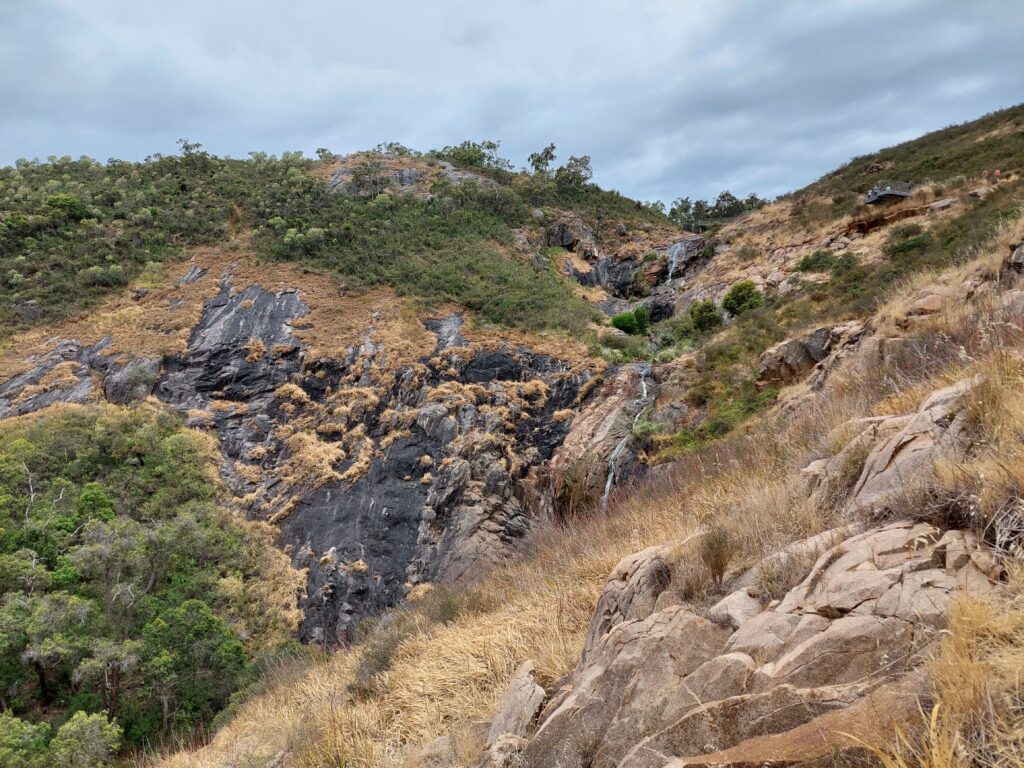
The dirt path was pretty much over and I started to climb rocks, a bit of a challenge but nothing really difficult. A short while later I got to the end of the road, and had a clear view of the falls (or at least one of the falls, I’m not too clear about that) from the bottom, or from the “foot” as it was called by the sign. It was a nice view, and the road to it was both fun and easy, and that alone felt like making my way over to the park was justified. Still, it was just the beginning of the trail and there were more things to see.
I turned around and made my way back along the rocks, and then the dirt trail, until I got back to the split in the road. Curious to see what it is all about, and wondering what is the story behind the name, I made my way up a mix of dirt trail and some stairs toward Lions Lookout.
Once more, a few minutes later I stopped. There was a fenced area which I thought was the lookout, where I had a bit of a higher view of the falls. While it was a nice view, it didn’t feel as special as I thought, judging by the name. Unless I was in the wrong spot. As I turned around, I noticed a somewhat questionable trail that kept going up. Wondering where it leads, I started following it. It became more and more narrow, and the bushes from either side made it difficult to pass. It is only for the footprints I saw that I kept going, thinking that if someone else has done it before then it is going to lead somewhere.
I kept climbing up the steep path and eventually I saw someone resting at the top. Feeling encouraged, it didn’t take long before I cleared my way and found myself in the middle of a path made of improvised wooden stairs. That made me question, again, whether or not the fenced area was the Lions Lookout. A likely, yet unverified, thought I had was that instead of taking the long and more comfortable way up to the next point of interest, The Head of the Falls, I unknowingly took a shortcut.
Clearing the stairs, I went along another dirt path before I got to a bridge with two lookout points. The second point was higher and seemed to be right on top of the waterfall, so I thought it could only be the The Head of the Falls. There was a nice view of the falls going all the way to the bottom, and on the horizon was the city hidden behind all the trees in the area. I stayed there to relax and enjoy the view for a little while before I kept walking along the bridge toward yet another point of interest in the loop trail.
At this point the rain started to fall. Quite weak and almost unnoticeable at first, but as I walked along the path it gradually became stronger and eventually I had to use my umbrella. The path was leveled for the most part, so while it was a bit of an inconvenience to use the umbrella, it wasn’t difficult.
There were quite a few splits in the road, and I just had to take a guess on where to go. There were barely any signs, and they weren’t very clear. I thought back to the trail up to the summit in Adelaide, and it made sense that the trails might be color coded. Still, a proper sign to show the way would have been nice.
At some point I saw some houses, and as I kept walking on the path I saw a car park with some picnic tables next to it. Feeling a bit confused, it took me a few moments to realize there is more than one entrance to Mundy Regional Park, which actually makes sense.
The rain didn’t stop, and neither did I. The next point of interest was called “The Cascades”, and I’m not sure if I managed to get there in the end. This was the point where I started to consult the navigation apps on my phone, trying to figure out where I am, where I’m trying to go, and just how far I can go.
And so I kept walking, for a while on a concrete trail, but soon enough it was replaced with the dirt trails which had quite a few splits in the road. Feeling more and more confused, I just kept going along one trail for as long as I could, thinking it had to lead somewhere.
There were some bends in the road and it started to go downhill, with some steep angles in parts of the trail. I kept walking, careful not to slide and fall over, all the while carrying the umbrella over my head as protection from the rain. The road was narrow, and some of the bushes around were thorny and unpleasant to the touch, so I tried to be more careful around those as much as I could. And then the road ended. I had no idea where to go, and there was nowhere to rest and hide from the rain.
Confused and frustrated, I took another look in my navigation apps. According to the maps, it seemed I had missed a turn in the road. Slowly and carefully, I traced my way back until I got to the point where there was supposed to be another trail, but I didn’t see anything. I walked a bit further ahead to see if I could spot any trail, and then I went back. With lack of other options, I concluded that a very narrow patch of land which was practically covered by bushes. With a doubtful mind I started walking, thinking that at any moment this so-called “trail” would be completely impassable and I’ll have to turn back. To my surprise, I was proved wrong very quickly, as the trail opened up a bit after I cleared quite a few bushes. Turned out it really was the trail I needed, it just lacked any kind of maintenance.
I kept on walking, wondering how anyone could have considered the bushes to be a trail, as I made my way over to the last point of interest in the loop trail, “The Shoulder”, relying quite heavily on the navigation apps at this point.
The rain was slowing down and it stopped almost at the exact time that I got to another little fenced area, which the smartphone indicated was the last point of interest. I could finally close the umbrella and put my hand down. There was a trail going down from there, and in hindsight I probably should have taken it. But as I got to the area, I finally saw two other hikers, who weren’t so sure that this was the correct spot, saying they saw another one along the trail. Wondering what they were talking about, I headed in the direction from which they came, instead of going down.
The road kept splitting in different directions, and I tried to follow some markers, but it was just too confusing. If there was another observation, I completely missed it.
At this point I started making my way down, or rather I started walking on a trail I thought was going down. Even with the navigation apps, it took me quite a while, and I’m pretty sure I made more than one wrong turn along the way, making the whole thing longer than it should have.
I did manage to get back to The Head of the Falls, and from there I took the stairs on the longer road, which was supposed to be easier. It wasn’t, and despite being so close to the starting point, I still made some wrong turns. Even so, this confusing hike took me less than two hours.
It was a good workout, for most of the way there were nice views, and the physical challenge wasn’t difficult. The lack of signs and proper guidance along the way on the other hand, was very annoying and frustrating. Better signs, and better weather, could have improved the whole experience quite a bit.