Souls’ Valley, Museum of Natural History, Palca Canyon, Lake Charquini, Seven Lakes
Another easy hike in La Paz was in Souls’ Valley, which was only a bit further away than Moon Valley. This time, I went on my own. I thought it would be pretty straightforward, just find the minibus that heads to the area and wait until the last stop. In theory, that was an easy and straightforward plan, but when I actually found a minibus that goes to the area, the driver wasn’t sure where I wanted to be dropped off, and when we got closer, he actually told me to switch minibuses and go with another driver, who dropped me after what Google Maps marked as “Laguna Uni” and Maps.Me marked as “Laguna de Animas”.
Looking at the maps on my smartphone, it seemed there were multiple starting point and hiking trails in Souls’ Valley, but since both apps had the same viewpoint which was supposedly at the end of those trails (or at least, a high viewpoint within the valley) I didn’t think it mattered too much.
I took a quick look around at the beautiful scenery around the starting point and started walking along an interesting dirt and gravel road. As far as I could tell, the trail went up and immediately into the valley. There were impressive cliffs on both sides, and I felt like this was what the Moon Valley was missing.
A couple minutes into the hike a dog decided to follow me. After some time walking the incline of the trail got more noticeable, and I quickly found myself on top of the relatively narrow area of the valley I just walked through. Looking behind me, I couldn’t see much of the city, but I still had a beautiful view to look at.
I looked at the maps several times, which seemed a bit pointless. The trail more or less kept going up and straight, and while there was plenty of room to deviate and explore different parts of the valley, I had my mind set on the viewpoint. Since I noticed a lot of blue lines on the maps, I assumed it was referring to rivers and streams and dried a long time ago, and I was in quite a dry area. Once again, I was thinking a Western or SciFi movie could easily take place in this area.
Walking around in the open space, I had less shade but since it wasn’t hot it didn’t really bother me. I kept going up, and the dirt road had quite a few plants and bushes dotted around it, which added to the variety of the scenery as well as the feeling I got from it. And since it was just me and a wandering dog, it was pretty quiet.
Then the incline started to be a bit more noticeable, and I wondered where was the trail to the view point, since there were no markings. I checked the smartphone again, then looked ahead, and wasn’t sure that I’m heading in the right way, even though I did according to the map.
Not long after it it dawned on me that the viewpoint marked as “Mirador Este” on Maps.Me might be the cliff wall I was looking at in the distance. As it turned out, I was right. I got as close as I could before the road started to get really steep, still questioning myself, and was about to turn around when I saw a pillar-looking thing at the top that looked man-made, although I couldn’t quite figure out what it was.
Curiosity took over, and I wanted to see if I could get at least a little bit closer to the object. At that point, the dog from the start of the trail was getting ahead of me. I wasn’t sure if the dog was trying to show me a safe path to the top, or just running around a lot more easily than me, but I tried to follow to the best of my ability.
I was slow, since the steep incline was a bit worrying and I didn’t have any other person with me in case something happened. Little by little, I made my way up. On the slope of the mountain, with no proper road, there was nowhere to stop for a proper break, but I did pause a few times to catch my breath and figure out how to get to the top.
I was getting closer, and then I was close enough to determine the object I saw earlier was indeed a pillar, made out of wood. I climbed higher still, and noticed some wires. When I finally got to the pillar, I found it to be the small viewpoint, Mirador Este, and it was quite a view.
I could see the city of La Paz in the horizon, beyond mountains, cliffs, and stone spirals which created a unique picture that made the somewhat dangerous climb worthwhile. On the other side I could see a snowy mountain, standing out with its white color, a sheer contrast to the shades of brown and yellow around me.
The viewpoint stood on top of a ridge, and there was a drop on either side. The wooden pillar did make me curious, though. There were quite a few on top of the ridge, all connected with barbed wire, but only one of them was standing. I wondered why it was there, and whether it was knocked down by nature or by people. I didn’t have any answers for those questions, and since I couldn’t see a clear and safe path to the main viewpoint which I initially wanted to get to, I took a short break and then slowly and carefully made my way back down. The whole thing took less than three hours, but I could’ve easily explored more paths and made a full day out of it. Maybe if I wasn’t by myself.
On the way back to the hostel, I stopped in the Museum of Natural History. It didn’t have any signs in English, but I still gave it a go, and tried to take in as much as possible. There were a few different galleries, including a cave-like area (made of paper) where the bats live, a gallery dedicated to describing the migration of fish (and the struggles they face), and a gallery about Andean cats, which I have never seen before. While I missed quite a lot, what I did manage to learn about the wildlife of Bolivia was quite interesting, and I was pleased with making this stop along the way.
Another hike that I could do on my own around La Paz was the Placa Canyon, a hike that normally starts at Uni. Getting to Uni wasn’t difficult, and the hike itself started pretty easy. It was all down a dirt road which was also suitable for vehicles, and there were nice views throughout. However, after about an hour and a half I got to what seemed to be a landslide, and the road was blocked. I tried to find a way around it for a little while, before taking a little break and returning back to Uni.
Going on another organized tour, after a scenic drive along a gravel road, I was at the base camp for Lake Charquini. Along with a small group and a guide, I started making my way up along the road with great sights all around. The mountains, snow, and partially frozen stream came together in harmony, and once more made me feel like I could be walking into a western or a fantasy movie.
For a change, I wasn’t the weak link of the group (although it did include a child), and not too long after we started walking, while having a short break, the guide said I could keep going up without waiting, and I was quite happy to do so.
Without a couple of minutes I already put a significant distance between myself and the group, and then they disappeared from view. It was just me, the wind, and the mountains. Ahead of me I could see some snow and ice, while every time I looked behind I saw a bit more of the brown mountains. The sand and the rocks created something unique, and even though I have seen similar sights before, it was just as beautiful and interesting to look at.
After a little while I saw some people ahead of me, but they quickly disappeared behind a bend in the road. However, after a bit more walking I found them taking a break. They were a family of three, and I stopped for a quick chat before wishing them good luck and continuing upwards.
I was by myself again, free to make my own pace and stop to take some photos without getting in anyone’s way. It didn’t take long before I saw more people ahead of me, although I didn’t catch up with them until I got to the lake.
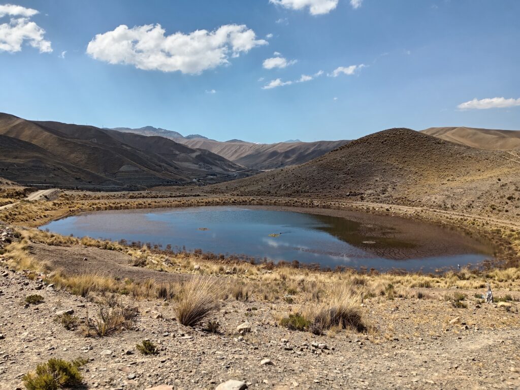
It was too far away, and I was actually surprised when I got there, thinking it was supposed to take longer. I was also surprised by the sign, which referred to the place as “Laguna Esmeralda”. It was a beautiful, frozen lake, which is not something I could remember seeing before. A few people went out to the middle of it to take some pictures, and after looking around for a bit, I sat down to rest, drink, and wait for my group to catch up. It took them about half an hour, and since I started to get bored I quickly made my way back down to wait in the more comfortable (and warm) minivan to get back to the city.
The last thing I did in La Paz was a visit to the Seven Lakes, an area not far from the center where seven small lakes were clustered together. Since it wasn’t talked about much, I first had to figure out how to actually get there. With the help of the nice receptionist at the hostel, I found out I had to go to Plaza Alonso de Mendoza, and from there take the bus to Caja Ferroviaria.
The ride took about half an hour, and I got off the bus at the last stop, which was marked as “Seven Lakes”, although it wasn’t right by the lakes. The bus seemed to stop at the end of the paved road, and then I had some walking to do along a dirt road in order to get to the lakes. It was a fairly easy walk, without any steep parts and with nice views to look at.
After fifteen minutes I was half way through, at a point where there was a split in the road, which on the maps on my smartphone seemed like a short path, but both maps insisted that I stay on the main road, and since the road that branched out appeared blocked I didn’t think too much of it.
Fifteen more minutes passed, and I got to another entrance, this time with a sign that had a bit of information about the area and also a map. The path in this map didn’t look exactly like what I had on my phone, and I stood there confused for a bit, wondering what to do. I decided to just go to the furthest lakes along the main road, and then make my way back to the start point along the path between the lakes.
I walked a bit more on the main road, and then I saw the first lake, to my right. It wasn’t particularly big, but it was still nice to look at. I found a turning point of the main road and then I was finally starting the trail. Since all the lakes were close to each other, within minutes of starting the trail I came across the second lake, this time to my left. It was a bit small, but just as nice, but it was the scenery around it that really made it feel elevated and a bit more special.
Between those two lakes there was a hill, and although there was no path to get there, it wasn’t steep or difficult to get to the top of it. From there I had a better view of the mountains and the surrounding area. I took a little break there to drink a little and enjoy the view before continuing onwards.
The trail went along the first lake, and then up to another hill, from the top of which I could see the next three lakes, straight ahead of me. It was a beautiful sight, but I wanted to get closer and didn’t spend much time there. I went down a bit, and quickly was at the edge for lake number three.
From there there was a clear trail to the next two lakes, however, when I got to lake number four I consulted the maps again, and saw that the final two lakes should be to the left, and not ahead. I found the trail that left to a small lake, but then had to go back as the path seemed to end.
It was in a similar manner with lake five, and lake seven which was so small I could have considered it to be a pond. It took a bit more than an hour to go all around the place, and while none of the lakes stood out as special on its own, together they were fun to visit, and a good way to end my time in La Paz before moving on to other parts of Bolivia. I sat down by lake number five to have a lunch break before making my way back to the bus.