Cima Charquini, National Museum of Ethnography and Folklore, Devil’s Tooth, Moon Valley
So far, my tendency was to take it easy when getting to a new country, but after I crossed the border from Peru to Bolivia and checked into a hostel in La Paz, I decided to start with something more intense. After looking around at some options, I booked a tour to Cima Charquini, a one day hike to the top of a mountain close to Huayna Potosí, which included a glacier and rock climbing sections.
Since the departure time was early in the morning, I wasn’t able to eat breakfast in the hostel. Instead, I got a packed bag with some snacks in it. After a short drive we stopped at a gear rental shop, where I got shoes, backpack, gloves, crampons, and harness. There was also another packed bag of snacks which waited there.
Other than me, there was a local couple who joined me on this trek, and our guide, who spoke both Spanish and English. He was quite active during the ride from the rental shop to Huayna Potosí base camp, talking about the day we were going to have as well as other places in the area and the wildlife we might come across. When we did get to the base camp, we had to pay the entrance fee, and then we finally started the trek.
Immediately, I sensed a problem. As the trail started with going up, I started to struggle with my breathing, which surprised me. Not that long ago I was in Huaraz, and while I spent more time than necessary in Cusco without doing much, I didn’t think the altitude would be difficult, nor the fitness level. If there was another problem, then it flew above my head.
Very quickly I was in the back, and at some distance. The group, whether by choice or not, has split into three- the guide in front, the couple in the middle, and me in the back. We had a bit of a gap between us, although we could see each other pretty much most of the way. Every now and then the guide would wait until the three of us reached him, and then kept going.
After the initial climb we got to what the guide called an “aqueduct”, and a more leveled section, with a stone wall one on one side and a cliff on the other. Along the way we stopped near a memorial to a traveler who tried to do this trail on a motorcycle many years ago and fell to his doom. We quickly moved on from there and the next stop we had was at a turning point.
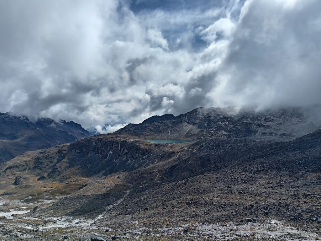
The leveled road kept going to Lake Canada, and we didn’t take it. Instead, we started going up again, along a trail that didn’t look like a trail at first, and made me glad I didn’t attempt it on my own. I struggled with my breathing even more, falling further behind.
I had more stops on this road, as I needed to catch my breath more than I would have liked, and whenever I could I looked around at the view around me. In the beginning it was quite stunning, but as time passed by and the clouds came in it became a bit of a challenge to fully enjoy the view and the experience.
At one break the guide pointed at the glacier and said we have about half an hour until we get there, and at that point I questioned whether or not I’m going to get to the top of the mountain. While I was discouraged by the distance, the altitude, the physical effort I knew will be required during the glacier section, and the cold, my biggest concern was the view. Looking up, the clouds covered the top of the glacier, which wasn’t even the top of the mountain.
I thought it would be best to at least get to the base of the glacier before making a final decision, although I wasn’t optimistic about it. The changing view was a helpful distraction as the little group made it way up, and when we took one final break the sun came out for a little bit, before quickly hiding between the clouds once more. For me, that was it. I didn’t see any point getting to the top of the mountain just to say that I got there. There was no view, and therefore no point in going up any higher. After talking with the guide, he gave me a radio so we could communicate and send me on my way back down.
The immediate descent was a bit tricky. I had my trekking poles in one hand and the radio in the other, so I could grab anything else. I had to try and look at a path down, as I failed to see any tracks, and that took me a few minutes. The road was still going down, and for a short distance it was a bit more leveled. I also spotted a couple of people going up, seemingly without a guide, but with a snowboard. I wasn’t sure how much use they were going to get out of it at Charquini, but it was their concern, not mine.
I went down more into a valley-like section, and there it was easier to notice tracks that I could follow safely back to the starting point. I still had a long way down, and somewhat regular check-ins with the guide to make sure I’m okay, but I didn’t have to worry about getting lost.
It took me a long time, but eventually I made it to the aqueduct section, where I took a little break to rest, drink, and catch my breath. The rest of the road was pretty easy, without any steep angles. It was still a long road, and it took me around 40 minutes before I got back to Huayna Potosí base camp.
I waited in the minivan with the driver, a bit longer than expected (at one point the people who work at the base camp seemed worried and wanted to talk with the guide over the radio), and since I forgot to take my earphones with me, that waiting time felt longer. When the guide and the other two travelers showed up, we had a long drive back to La Paz, where after having dinner I quickly went to bed. That trek was much tougher than I thought it would be.
Feeling the need to relax and take things a bit easy, I went over to the Coca Museum, but it was closed at the time I got there. Instead, I went to the National Museum of Ethnography and Folklore, which was within a short walking distance. At the entrance to the museum it turned out that with a regular ticket it is forbidden to take pictures or video, and anyone who wants that can pay extra. Even though it wasn’t the first time I’ve come across this, it was still annoying.
I paid for the regular ticket and entered the first gallery of the museum, which was about textile in general, in Bolivia and in nearby areas. It described the processes and the different materials being used, in addition to having several items on display. While the signs were only in Spanish, I did manage to understand quite a bit of it.
The second gallery was titled “hats”, which felt misleading to me. There were full outfits in this gallery, with some of them having a hood, and others with hats. It was divided into two main sections, one for men’s outfits and the other for women’s outfits, showing how it changed over time from the Pre-Inca civilizations all the way to post-colonial times. At the very end of that section there was also a section dedicated to hats from different regions of the country.
The third gallery was about masks, both ancient and modern. The gallery featured quite a few exhibits, talking about their uses, from parties to religious ceremonies and cultural symbols. I got a bit bored of this section, and moved on rather quickly.
Next was the ceramics gallery, which didn’t have much explanation in it. It was a decent collection of artifacts, and next to each other there was a label with very minimal explanation regarding its origin, but unfortunately not much else.
Crossing a hallway and going into gallery number five, I learned a bit about “feather art”, how the ancient civilizations who lived in this area used feathers of different birds to create various items, mostly for clothing. There were also a few birds on display, with signs that got me a bit lost. If I understood them correctly, those signs were telling some mythical stories on why the feathers of those particular birds were used instead of others.
After that I got more confused and a bit bored, so I looked around at a couple more galleries, one of which features an art exhibition of what ancient life was like in different parts of Bolivia, and then left the museum.
Going for a significantly easier and shorter hike, along with three other backpackers, I headed to the Devil’s Tooth, an easy hike not far from the city center of La Paz, and most of it can be done with a vehicle. Our little group, however, used public transport, which dropped us off on a dirt road and quickly disappeared from view.
While the road wasn’t steep, it was definitely an incline, and once more I found myself struggling to breath. I paced myself as much as I could, slowing down and taking deep breaths. The other members of the small group seemed to struggle less than I did, but we were all breathing a bit heavily at some points along the trail.
On the bright side, from the very beginning we had great views of the city below us and the mountains on the horizon. It was quite a unique view, especially with how crowded La Paz looked, and I struggled to recall similar sights in other countries that I visited.
Other than the changing view, which was great all the way through, we chatted a bit and took some photos. After a short while we passed an arch which welcomed us to a new part of the city, which was very quiet. At that point I needed to talk with some family members, and stayed behind while my fellow backpackers carried on. It took longer than I anticipated, and by the time I got off the phone, I didn’t see my group in sight.
Thinking I’ll see them soon enough, I wasn’t worried, and without another option I started walking along the dirt road on my own. Here, the city sights were behind me, and they were replaced by mountainous scenery which very easily captured my attention. The shape of the terrain was unique and interesting, and I was quite happy looking around on my own.
Along the way I passed through a small neighborhood (or perhaps it should be called a village), and at the end of it I heard someone yelling my name. When I looked up I could see my travel companions for the day, although they were quite far away from me, and didn’t wait for me along the trail.
The trail went down for a bit, then leveled and quickly went up. By the time the incline became more moderate, I wasn’t able to see anyone. Luckily, the road was easy to follow and I wasn’t in any danger of getting lost or injured. It wasn’t a short road, though, so it took me a little while, but eventually the incline leveled more, and I saw the sign indicating that I got to the viewpoint of the Devil’s Tooth. There, I finally reunited with the other three backpackers and sat down for a short rest.
While the views from the viewpoint were great, the trail wasn’t over yet. It was time to climb the tooth itself. This road was a bit more challenging, as we had to climb some rocks on the way along a steep section. It wasn’t long, but we still stopped at a couple of points to catch our breath, take a look at the view, and try to figure out what is the easiest (and safest) route to get to the top.
When we did get there, we saw some people going down, and we had a brief chat with them before they disappeared from view. The group didn’t feel the need to stay up for long, and while discussing the plan of what to do next we figured it would be best to go back down to the viewpoint first.
We managed to catch up with the people we saw going down, and after asking them about the Moon Valley, they kindly offered us to ride back with them (they drove all the way to the viewpoint) and dropped us off back in the city, where we were able to use the public transport.
At that point, one of us had to go back, leaving three to tour the valley on their own. We paid the entry fee, and right after we passed the entrance there were two trails, one that takes 15 minutes and one that takes 45 minutes. We didn’t need to think much of it, and set foot along the longer trail.
The road took us over the valley, so we had a good view of all the stone and clay spiral formations, which were interesting to look at. I thought it was unfortunate that there was no trail going into the valley, as the view from the bottom would’ve been undoubtedly exciting. It also made me feel like that whole part of Bolivia, or at least of La Paz, would have served as a great setting for Western Movies.
Our little trio made its way around, taking our time and enjoying the views of the Moon Valley, while being unsure as to how it got that name. We could also see the Devil’s Tooth from there, which seemed quite far away even though we were just there. Eventually the trail was completed, and after one last look from the top we left the site and went back to the hostel.